About OsmAnd — Maps & GPS Offline
OsmAnd is an offline world map application based on OpenStreetMap (OSM), which allows you to navigate taking into account the preferred roads and vehicle dimensions. Plan routes based on inclines and record GPX tracks...
OsmAnd is an offline world map application based on OpenStreetMap (OSM), which allows you to navigate taking into account the preferred roads and vehicle dimensions. Plan routes based on inclines and record GPX tracks without an internet connection.
OsmAnd is an open source app. We do not collect user data and you decide what data the app will have access to.
Main features:
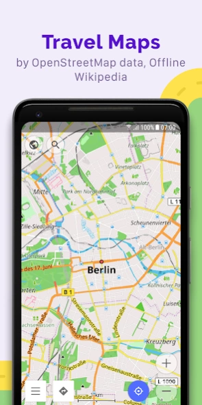
Map view
• Choice of places to be displayed on the map: attractions, food, health and more;
• Search for places by address, name, coordinates, or category;
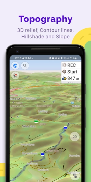
• Map styles for the convenience of different activities: touring view, nautical map, winter and ski, topographic, desert, off-road, and others;
• Shading relief and plug-in contour lines;
• Ability to overlay different sources of maps on top of each other;
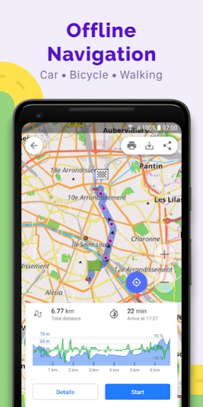
GPS Navigation
• Plotting a route to a place without an Internet connection;
• Customizable navigation profiles for different vehicles: cars, motorcycles, bicycles, 4x4, pedestrians, boats, public transport, and more;
• Change the constructed route, taking into account the exclusion of certain roads or road surfaces;
• Customizable information widgets about the route: distance, speed, remaining travel time, distance to turn, and more;
Route Planning and Recording
• Plotting a route point by point using one or multiple navigation profiles;
• Route recording using GPX tracks;
• Manage GPX tracks: displaying your own or imported GPX tracks on the map, navigating through them;
• Visual data about the route - descents/ascents, distances;
• Ability to share GPX track in OpenStreetMap;
Creation of points with different functionality
• Favourites;
• Markers;
• Audio/video notes;
OpenStreetMap
• Making edits to OSM;
• Updating maps with a frequency of up to one hour;
Additional features
• Compass and radius ruler;
• Mapillary interface;
• Night theme;
• Wikipedia;
• Large community of users around the world, documentation, and support;
Paid features:
Maps+ (in-app or subscription)
• Android Auto support;
• Unlimited map downloads;
• Topo data (Contour lines and Terrain);
• Nautical depths;
• Offline Wikipedia;
• Offline Wikivoyage - Travel guides.
OsmAnd Pro (subscription)
• OsmAnd Cloud (backup and restore);
• Cross-platform;
• Hourly map updates;
• Weather plugin;
• Elevation widget;
• Customise route line;
• External sensors support (ANT+, Bluetooth);
• Online Elevation profile.
Previous Versions
Here you can find the changelog of OsmAnd — Maps & GPS Offline since it was posted on our website on 2013-08-23 11:48:31.
The latest version is 4.6.13 and it was updated on 2024-03-20 03:27:10. See below the changes in each version.
OsmAnd — Maps & GPS Offline version 4.6.11
Updated At: 2024-01-29
Changes: • Android Auto: Added 3D mode
• Tracks: Introduced filters and smart folders, optimized memory for larger files
• Enhanced top and bottom widget panels to accommodate all widgets
• Improved local resource management
• Customizable button mapping for external controllers
• New widgets: "Glide Ratio" and "Sun Position"
• OsmAnd Cloud: Now access deleted files
• Enhanced track coloring in Slope mode with new symmetric gradient
• Resolved issues with transparent status bar
OsmAnd — Maps & GPS Offline version 4.6.13
Updated At: 2024-01-29
Changes: Fix crashes
OsmAnd — Maps & GPS Offline version 4.5.10
Updated At: 2023-12-15
Changes: • BLE/ANT+ sensors: reworked connection, writing and viewing received data to GPX
• Free backup for favorites and settings to "OsmAnd Cloud"
• New format for Terrain maps with 3D Relief support
• Tracks management: updated UI, added sorting, support of nested folders
• Android Auto: new start menu for access favorites, tracks and POI categories
• One list of widgets for the Top/Bottom panel
• New "Train" profile, allows to calculate railways routes
OsmAnd — Maps & GPS Offline version 4.4.7
Updated At: 2023-07-20
Changes: • Improved "Tracks" menu in "Configure Map"
• Context menu now displays localized names for POI
• Added option to share route by link
• Added "Nautical miles/feet" unit of length
• Map orientation added new fixed mode
• Simplified start screen
• Fixed location position in split screen mode in Android Auto
• Added "Speed/Slope" graph for track analysis
• Android 13 moved app language selection to system settings
• Fixed issues with displaying Vegan places
OsmAnd — Maps & GPS Offline version 4.3.12
Updated At: 2023-03-28
Changes: • New, faster Version 2 (OpenGL) map rendering engine, with 2.5D view
• Smooth animation of location changes while in motion
• New widgets for map center coordinates and elevation of geolocations
• "Distance to tap": added text size options
• "Map marker" widget: added option to change click behavior
• Fixed "Display position" option
• GPX: added support for "link", "cmt", "desc" tags and for any custom extensions
• Reorganized "Nautical maps" list
• Added support for ANT+ sensors
OsmAnd — Maps & GPS Offline version 4.1.11
Updated At: 2021-12-15
Changes: . Added initial support for Android Auto
. User interface update for UTM coordinate search
. GPS Filter for GPX Tracks
. Elevation Widget (Pro)
. Favorites: added ability to view recently used icons
. Route planning: will use the selected profile after launch
. Fixed Mapillary layer, the plugin is now disabled by default
. Added screen to manage all history in the app
. Map orientation is not reset after restarting the app
. Improved SRTM height marker rendering
. Fixed Arabic map captions
OsmAnd — Maps & GPS Offline version 4.0.8
Updated At: 2021-11-18
Changes: . Cloud backup
. Added night mode for "Topo" rendering style
. Added option to download Contour lines in feet
. Tracks can now be colored by altitude, speed, or slope.
. Updated "Trip recording" dialog
. Distance by tap moved from the Radius ruler into a separate option
. Plan Route: added ability to change navigation options, accessing configure map and search without leaving plan route
. Added option to change the route line appearance.
OsmAnd — Maps & GPS Offline version 3.9.10
Updated At: 2021-08-05
Changes: . Added option to export and import all data including settings, resources, my places
. Plan Route: graphs for track segments with route, and added the ability to create and edit multiple track segments
. Added OAuth authentication method for OpenStreetMap, improved UI of OSM dialogs
. Support custom colors for favorites and track waypoints
OsmAnd — Maps & GPS Offline version 3.8.3
Updated At: 2020-10-29
Changes: . Updated "Plan Route" mode allows using different navigation types for each segment and attaches any track to the roads
. New "Appearance" options for tracks: select color, thickness turn on the direction arrows and start/finish marks
. Improved bicycle nodes visibility
. Context menu for tracks with basic info
. Improved "Search" algorithms
. Improved "Follow track" options in Navigation
. Fixed issues with import/export of profile settings
OsmAnd — Maps & GPS Offline version 3.7.4
Updated At: 2020-09-22
Changes: . New offline Slope maps
. Full customization of Favorites and GPX Waypoints - custom colors, icons, shapes
. Customize items order in Context Menu, Configure Map, Drawer
. Wikipedia as a separate layer in Configure map, select only needed languages
. Create your own POI filter/maps with total flexibility
. Added options to restore settings for custom profiles
. Full GPX routes from Navigation support traffic lanes and complete turn instructions
. Fix UI sizes on tablets
. Fix bugs with RTL
Disclaimer
Official Google Play Link
We do not host OsmAnd — Maps & GPS Offline on our servers. We did not scan it for viruses, adware, spyware or other type of malware. This app is hosted by Google and passed their terms and conditions to be listed there. We recommend caution when installing it.
The Google Play link for OsmAnd — Maps & GPS Offline is provided to you by apps112.com without any warranties, representations or guarantees of any kind, so access it at your own risk.
If you have questions regarding this particular app contact the publisher directly. For questions about the functionalities of apps112.com contact us.